St. Anton am Arlberg -
Via Ferrata
Arlberg via ferrata
State
Locked until cancelled!
Difficulty
D
Via Ferata length
2752 m
Via Ferata height
400 hm
Sea Level
2646
-
2752 m
Exposure
W
Best season
Jul - Sep

GPS Position / Ascent
All real-time data of the infrastructures can be found in the
fullscreen view of the interactive map
Austrian Mountain Rescue Tel: 140 Emergency call for all of Europe: 112
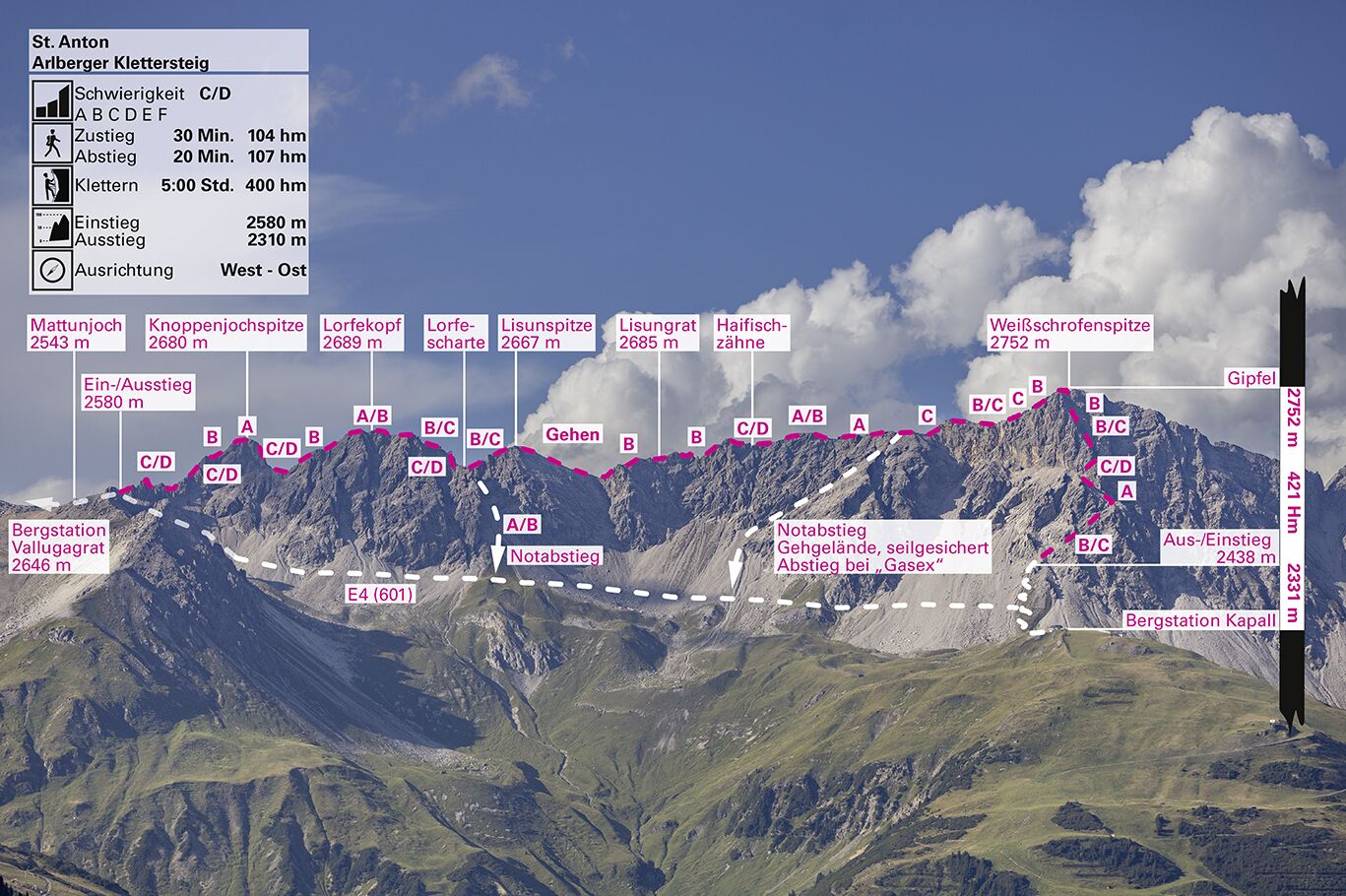
After a few metres, the 1st tower already has a key section - a vertical descent of 20 metres. Around the 2nd tower you can recover again before the big climb up to the 2,680-metre Knoppenjochspitze. This is the key section of the via ferrata, in almost vertical but still well-structured rock. After the descent from the summit of the Knoppenjochspitze, it is an easy climb to the summit of the Lorfekopf (2,689 m). The descent is somewhat difficult. Those who do not want to do the full length of the via ferrata can now descend from the Lorfescharte and hike comfortably to Kapall. If you are fit enough and want to continue, go up to the Lisunspitze (2,667 m) and over the Lisungrat (2,684 m). There and at the "Haizähnen" (shark's teeth), you walk over airy spikes and towers. After the "Haizähnen" you can recover a little until the tour leads to the highest point, the Weißschrofenspitze (2,752 m). You can now enjoy the magnificent view down into the Almjurtal valley or the panorama of the Allgäu Alps on the left and the beautiful ski slopes of St. Anton on the right. After a short rest, descend via the south ridge - a medium-steep descent - to Kapall.
Walking time approach
30 min
Climbing time
5 h
Walking time descent
1 h
Access
The best ascent is with the Galzigbahn, then with the Vallugabahn to the Vallugagrat station (2646m). From the cable car, descend east to Matunjoch (2543) (marked: be careful of snowfields). From the Joch (signpost) follow the markings to the entrance (signpost) below the first tower. Alternatively, you can ascend from the Arlberg Pass via the Ulmer Hütte to the Mattunjoch - but this approach is very long (total walking time approx. 9 hours).
Descent
Descend via the scree slope to the path. Follow the signs to the mountain station of the Kapall cable car or via the Mattunjoch back to the Vallugabahn.
Public transport
Bus or train.
Journey
From Bregenz or Landeck to St. Anton and park along the main road. Public transport: By train to St. Anton - the station is close to the Galzigbahn.
Parking
Galzigbahn car park - free of charge
St. Christoph car park - free of charge
St. Christoph car park - free of charge