Klettern - Climbers Paradise -
E-Bike & Climb
E-Bike & Climb - Silvapark Galtür (Ballunspitze via ferrata)
State
Locked until cancelled!
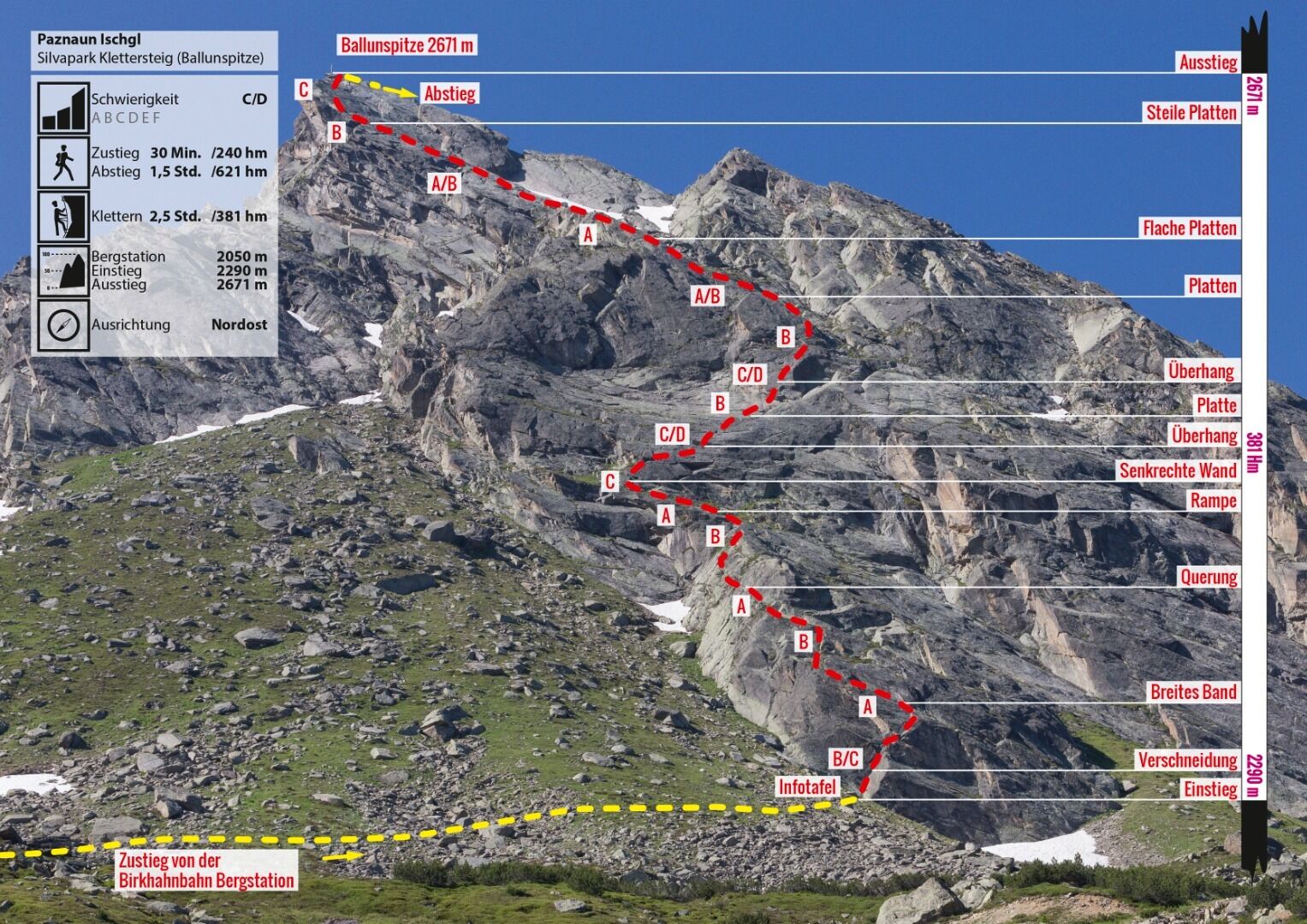
Difficulty
C / D
Via Ferata height
381 hm
Sea Level
2290
-
2671 m
Exposure
N
Best season
Jun - Oct

GPS Position / Ascent
All real-time data of the infrastructures can be found in the
fullscreen view of the interactive map
Download GPX
Climbing time
2:30 h
Walking time descent
1 h
Total Bike & Hike duration
4 h
Altitude metres Bike
423 hm
Bike route length
5.5 km
Altitude metres Hike
231 hm
Hike route length
1.2 km
Altitude metres Bike & Hike
654 hm
Bike & Hike route length
6.7 km
Approach Bike & Hike
Entrance:
Ascent with the Birkhahnbahn. From the top station of the Birkhahn cable car, follow the marked trail in the direction of the Kops reservoir and Breitspitze. In the area of the top station of the drag lift, a path (sign "Klettersteig") branches off to the left. Follow this trail almost to the bottom of the cliffs. At approx. 2250 m (N46 57.561 E10 07.827) the access path branches off to the left and you cross under the rock walls to the entrance.
Ascent with the Birkhahnbahn. From the top station of the Birkhahn cable car, follow the marked trail in the direction of the Kops reservoir and Breitspitze. In the area of the top station of the drag lift, a path (sign "Klettersteig") branches off to the left. Follow this trail almost to the bottom of the cliffs. At approx. 2250 m (N46 57.561 E10 07.827) the access path branches off to the left and you cross under the rock walls to the entrance.
End point bike / starting point hike
Faulbrunnalm
Descent
The descent
The descent via the path takes place in a north-westerly direction, always following the tracks of the path. The tracks are equipped with tread plates and handholds. At about 2,250 metres, you rejoin the access route, which you follow to the starting point - the Alpkogelbahn.
The descent via the path takes place in a north-westerly direction, always following the tracks of the path. The tracks are equipped with tread plates and handholds. At about 2,250 metres, you rejoin the access route, which you follow to the starting point - the Alpkogelbahn.
Public transport
With the railway station in Landeck, the Paznaun is optimally connected to the Austrian train network. From Landeck-Zams station, only a short bus ride separates you from the Paznaun. Every half hour, line bus 260 runs from there through the valley.
Bus stop: Galtür Wirl/Birkhahnbahn
Buses in the Paznaun valley | Region Paznaun – Ischgl
Bus stop: Galtür Wirl/Birkhahnbahn
Buses in the Paznaun valley | Region Paznaun – Ischgl
Legend:
🄷Bike
👶
🛬Hike
easy
medium
difficult
Singletrail