Ferienregion Imst -
Sport Climbing
Hahntennjoch / Anhalterhütte
🅟 Family friendly
State
Locked until cancelled!
Difficulty
4
- 7
Route length
25 - 32 m
Number of routes
11
Sea Level
2100 m
Exposure
N
Best season
Jul - Oct


GPS Position / Ascent
All real-time data of the infrastructures can be found in the
fullscreen view of the interactive map
The climbing garden is located in high-alpine terrain. There is also a multi-rope route up through the 400 m high wall. Always take into account the chance of rockfall - a helmet is obligatory.
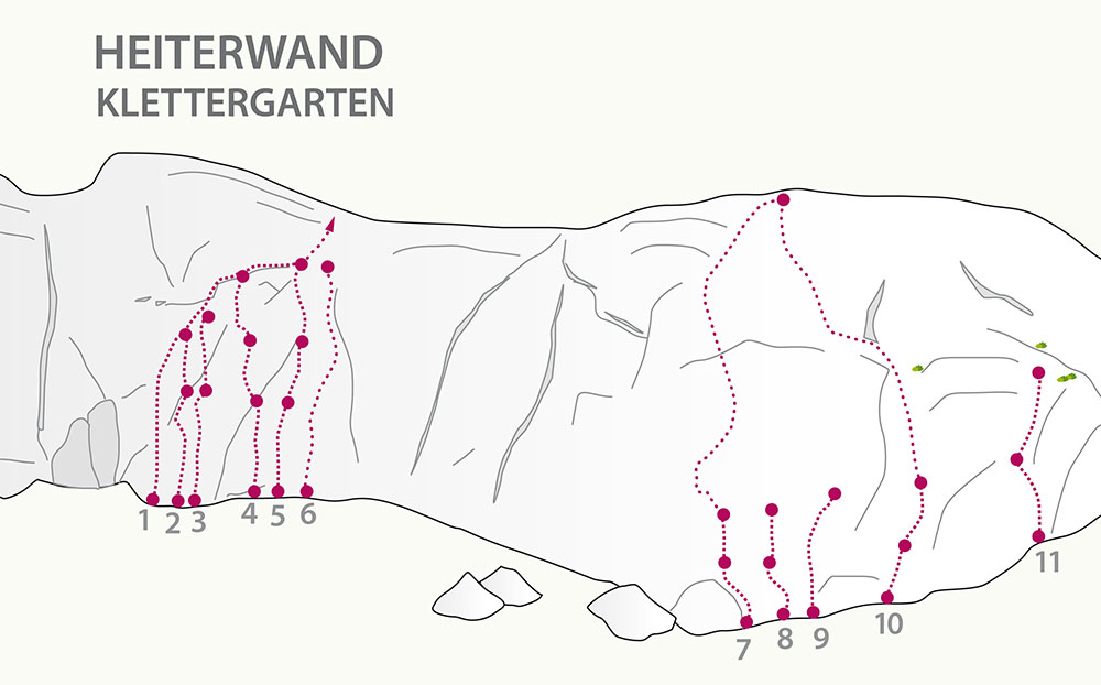
Route overview
level
Quantity
4
4
5
1
6
2
7
2
Project
2
Rock
Limestone
Walking time approach
45 min
-
1:15 h
Attractiveness
Protection
Access
1h 15 min
Journey
From Imst to the pass of the Hahntennjoch. Follow the hiking trail to the Anhalter Hut until the Kromsee (lake). Now up a steep slope to the foot of the wall of the Maldongrat.
1 hour 15 minutes from the Hahntennjoch
20 minutes from the Anhalter Hut.
1 hour 15 minutes from the Hahntennjoch
20 minutes from the Anhalter Hut.
Parking
begrenzte Parkmöglichkeiten bestehen auf der Passhöhe des Hahntennjoch.


Ferienregion Imst - Sport Climbing | Hahntennjoch / Anhalterhütte
Hahntennjoch / Anhalterhütte
Hahntennjoch / Anhalterhütte

Number of routes
11
Routes
1 Diagonale 1. Sl. (von drei)
5a
30 m
2 Trickkiste 1. Sl. (von zwei)
6a
30 m
3 Paterkapple 1.Sl. (von zwei)
6a
28 m
4 Flying Seppl 1. Sl. (von drei)
6b
28 m
5 Route 66 1. Sl. (von drei)
6a+
30 m
6 Delta B (Projekt)
7 Ölspur 1. Sl.: (von zwei)
3c
30 m
8 Mädchentraum 1. Sl. (von zwei)
4b
26 m
9 Punto Blue (Projekt)
10 Via Otti 1. Sl.: (von zwei)
4a
25 m
11 Germania 1. Sl. (von zwei)
4b
32 m