Tiroler Oberland -
Ice Climbing
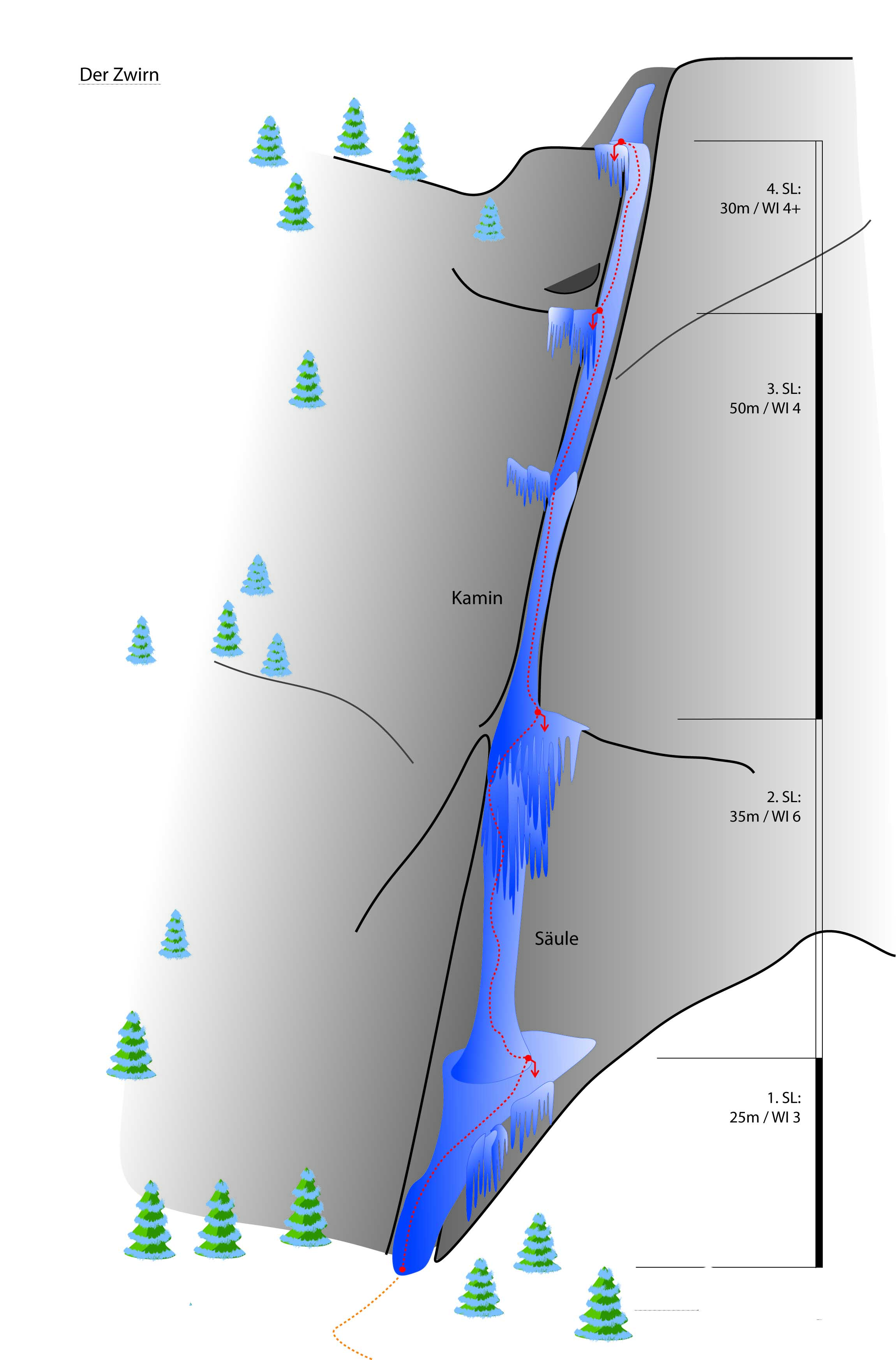
Zwirn - Kaunertal
Difficulty
WI 6
Sea Level
1500 - 1660 m
Route length
160 m

GPS Position / Ascent
All real-time data of the infrastructures can be found in the
fullscreen view of the interactive map
Spectacular waterfall surrounded by wild nature.
Approach: Toll station, Kaunertal
Ascent: ca. 150m behind the toll station turn right, cross the bridge (teepee). Turn left ca. 100 m before reaching the field, through a sparse tree forest, then follow the chute to the entrance. 30 minutes.
Descent: Abseiling on ice tunnels
Caution: the 4th pitch stand (2 short pitons) is from the year 1990 and in bad condition.
Public transport
Anreise per Zug/Bus:
Bahnhof Landeck/Zams - von dort mit dem Bus nach Prutz - von da dann mit der Linie 230 dem Bus ins Kaunertal. Fahrzeiten bitte beachten!
Bahnhof Landeck/Zams - von dort mit dem Bus nach Prutz - von da dann mit der Linie 230 dem Bus ins Kaunertal. Fahrzeiten bitte beachten!
Journey
Anreise per Auto:
Wenn Sie aus Norden kommen...
A7 Füssen/Garmisch - B 179 Fernpass - Imst A 12 - Landeck/Zams - Landecker Tunnel B 180 - Prutz - Kaunertal
Wenn Sie von Westen kommen...
Bregenz A14- Arlberg (Tunnel oder Pass) S16 - Landeck - Landecker Tunnel B 180 - Prutz - Kaunertal
Wenn Sie von Süden kommen...
Reschenpass - Nauders B180 - Pfunds - Prutz - Kaunertal
Wenn Sie von Osten kommen...
Wien - A12 - Innsbruck - Landeck/Zams - Landecker Tunnel - B 180 Prutz - Kaunertal
Anreise per Zug/Bus:
Bahnhof Landeck/Zams - von dort mit dem Bus nach Prutz Innbrücke - von da dann mit der Linie 4232 dem Bus zur Haltestelle Kaunertal Grasse. Fahrzeiten bitte beachten!
Parking
Mautstelle